


▶ Bridges & Underpasses (Active Transportation)
In a city of barriers, pedestrian/cycling bridges and underpasses are the connective infrastructure linking different parts of the City together. These links shorten the road distance between two points and enable safe active transportation over or under barriers for which there is no way around, e.g. the 401 highway, the Credit River. Such links are largely retrofit projects that weren't built when the City was almost exclusively car-oriented, hence they involve significant design and planning phases and are expensive to build. ▶ See also: Minimum Grid - Barriers & Gaps
Bridges, Tunnels & Trails Tour in SE Mississauga: September 21, 2025
[Updated: September 26, 2025]
The Town of Port Credit Assocation (TOPCA) conducted their annual bike ride (Poster at left) as a tour of bridge connections just built, being built, or newly planned to be built. The sites are listed below, #1-6.
It is cause for celebration whenever a new link is built, to safely connect parts of the potential cycling network and extend the locations that can be reached without a car. In southeast Mississauga, over fifteen (15) years have been spent by cyclists and residents advocating for specific projects to better connect the City with its waterfront and provide safe active transportation options in an area suffering from severe traffic congestion.
Active Transportation Bridges under Construction
[Updated: October 2, 2025]▶ See also from: Mississauga Construction Projects

1. New pedestrian/cycling bridge just south of the CNR bridge in Port Credit Memorial Park, connecting to the Port Credit GO Station. Construction begins Fall 2025 (Groundbreaking: October 2, 2025, see sidebar) for 2026 completion; it was originally in the City's capital budget for 2041. See: City's Port Credit Active Transportation Bridge webpage (source of concept image at left).

2. New AT bridge over the QEW to reconnect Stavebank Road North and South. See: MTO's QEW/Credit River Improvement Project. Concept image presented at the MTO public workshop in December 2017.

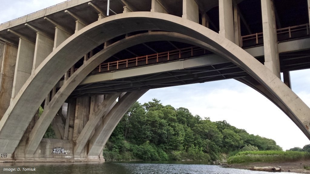
3. AT bridge over the Credit River, in the utility service corridor under the heritage bridge which was saved from destruction (MN article - 2019). NOTE: A separate trail project (2025-2027), 1km long, is underway at this site to connect the west and east parts of the Nine Creeks Trail with a bike-pedestrian crossing over Credit River. See: MTO's QEW/Credit River Improvement Project.

4. Ogden Avenue AT bridge over the QEW and North and South Service Roads to Applewood Plaza. The old bridge was rickety and rusting. The new replacement opened in December 2024 after a year and a half closure. See: MTO's QEW/Dixie Interchange Project (source of image at left).

5. The City received a $17 million grant from the Government of Canada’s Active Transportation Fund toward expanding the TransCanada Trail system, linking Lakefront Promenade Park to the west and Jim Tovey Lakeview Conservation Area (open Summer 2026) to the east. An AT bridge is planned with the continuation of the Waterfront Trail/TransCanada Trail. See: 'Waterfront Trail and pedestrian bridge EA' section & slide deck at City's Developing Parks in Lakeview Village webpage.

6. New (eastern) underpass at Hurontario Street and the QEW is part of the Hurontario LRT reconfiguration and accommodates traffic and a multi-use path for pedestrians and cyclists to access the North Service Road and Nine Creeks Trail. The original underpass is no longer to be used by pedestrians or cyclists. See: Metrolinx article (includes video) New underpass installed at Hurontario and QEW.
▶ Topical MCN! X Posts:
GOREWAY BRIDGE: *OPEN* Project area: Brandon Gate Dr in Malton to Kenview Blvd in Brampton. *NEW* Multi-Use Trail on east side connects to #MaltonGreenway 🌿 parks & trail system and to #BikeBrampton. Project 🔗: https://t.co/WbKIDVNTUC | News release 🔗 ⤵️ #bikeMississauga 🚲 https://t.co/HIUYWdacEW
— Mississauga Cycling Now! (@MissCyclingNow) October 17, 2025
PORT CREDIT ACTIVE TRANSPORTATION BRIDGE: 🎉 Ground broken! 📸: [tag] 🏗 Combined w/ AT bridge being built by MTO *over* QEW to reconnect Stavebank Road N & S there w/b a safe direct #cycling route to #WaterfrontTrail 🌊
— Mississauga Cycling Now! (@MissCyclingNow) October 3, 2025
➡️ MCN! 🔗: https://t.co/sSsqnrDxGf | #bikeMississauga 🚲 pic.twitter.com/mN4xjYjvNU
*NEW* ACTIVE TRANSPORTATION BRIDGE: 🎉 Needed infrastructure for walking and #cycling in #PortCredit with connection to GO 🚉 This was a stop on TOPCA's ~Bridges, Tunnels & Trails~ bike tour in Sept 2025. This & others ➡️ MCN! 🔗: https://t.co/sSsqnrE5vN | #bikeMississauga 🚲 https://t.co/7SGRcDHFaI
— Mississauga Cycling Now! (@MissCyclingNow) October 1, 2025
Two new pedestrian bridges are now in place at the future Jim Tovey Lakeview Conservation Area (#JTLCA)! 🚧🌉 These crossings will connect trails, boardwalks and lookouts across the 26-hectare waterfront site, transforming a former industrial space into a vibrant green oasis for…
— Credit Valley Conservation (@CVC_CA) September 26, 2025
LAKEVIEW VILLAGE WATERFRONT TRAIL & PEDESTRIAN BRIDGE: *TONIGHT* Thurs June 12 @ 6-7:30pm. Virtual PIC 💻👥💬 to review Class EA: location & design of the #WaterfrontTrail 🌊 extension and ped/#cycling bridge. Webex mtg link via 🔗: https://t.co/ukA5pUXxcq | #bikeMississauga 🚲 pic.twitter.com/JJqzcDMr7E
— Mississauga Cycling Now! (@MissCyclingNow) June 12, 2025
OGDEN AVENUE PEDESTRIAN-CYCLING BRIDGE: Demolition in March 2023 🌁💥 MTO Photo gallery 🔗: https://t.co/V6OAYMne78 | New (pre-fab) bridge installation 🌁🏗 over #QEW 🛣 plus SSR, NSR in Lakeview scheduled for weekend in late Aug 2023 (before school 🏫 starts) #bikeMississauga 🚲 pic.twitter.com/cdF7tyAcEF
— Mississauga Cycling Now! (@MissCyclingNow) April 4, 2023
ONLINE SURVEY: Open to *Tues May 10* 💻💬 re: Active Transportation bridge 🌁 over #CreditRiver 🏞 leading to #PortCredit GO Stn 🚉 First/last km infra = #cycling to transit! Part of ~Lakeshore Transportation Studies~ ➡️ Survey 🔗: https://t.co/yjnTeSKMhE | #bikeMississauga 🚲 pic.twitter.com/4uzw8gyBi5
— Mississauga Cycling Now! (@MissCyclingNow) May 9, 2022
QEW CREDIT RIVER IMPROVEMENT PROJECT: Comment 💻💬 by *TODAY* (Thurs Sept 2) per EDCO P.I.C. #1 (w/ Q&A) - Project Design for *rehab* of the QEW heritage bridge at #CreditRiver incl. two (2) #bikeMississauga 🚲 AT crossings 🏗 🛣 🌉 Slides, Materials 🔗: https://t.co/Egaq2gy6JH pic.twitter.com/2Ltizmj9SN
— Mississauga Cycling Now! (@MissCyclingNow) September 2, 2021
Copyright © 2025 MCN! - Mississauga Cycling Now! All Rights Reserved.